
If you see one thing in Belize, see the ATM cave. The whole trip takes 10hrs bring thick socks and change of clothes. Tikal is also easily accessible from here for a 2 day trip.
Sleep in a treehouse at the Parrot Nest lodge in nearby Bullet Tree Falls. From here you can tube down the river.
San Ignacio (Belize)
The area around San Ignacio is one of the most popular parts of the country for tourism. Nearby attractions include the ancient Maya ruins of Caracol, Xunantunich, Cahal Pech, and El Pilar. Notable caves to explore include the Actun Tunichil Muknal cave, which includes skeletons, ceramics, and stoneware, and Barton Creek Cave, which is popular among adventure tourists interested in cave canoeing.
San Ignacio is situated on the banks of the Macal River, about 63 miles (101 km) west of Belize City and 22 miles (35 km) west of the country's capital: Belmopan. The town has an area of approximately 2.5 square miles (6.5 km).
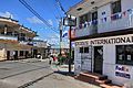 Street scene in San Ignacio
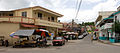 View of San Ignacio, looking towards the Hawkesworth Bridge
 Burns Avenue
 Small park of downtown San Ignacio in front of the police station
 Belize independence day celebration


Your notes (private)
What's on your mind? (you can type here notes just for you and they will show on your dashboard)
Information for getting there
When someday comes you'll need to get in.
Information for getting around
When someday comes you'll need to be able to get around.
Your tips and questions
Let us know your best tips about San Ignacio (Belize).